Sunday, 8 January 2012

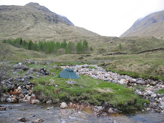
Hiking trip Scotland Isle of Skye, Cuillin hills 2010


This was my first real hiking with my nearly 9 year old son. The plan was to go to Scotland and to decide based on the weatherforecast where we would go. The Cuillin hills at Skye was the place to go. We made our trip in May 2010.


Skye or the Isle of Skye (Scottish Gaelic: An t-Eilean Sgitheanach or Eilean a' Cheò) is the largest and most northerly island in the Inner Hebrides of Scotland. The island's peninsulas radiate out from a mountainous centre dominated by the Cuillin hills.

The Cuillin (Scottish Gaelic: An Cuilthionn or An Cuiltheann) are a range of rocky mountains located on the Isle of Skye in Scotland. The true Cuillin are also known as the Black Cuillin to distinguish them from the Red Hills (Am Binnean Dearg) across Glen Sligachan. The Red Hills are lower and, being less rocky, have fewer scrambles or climbs.

Details
  • easy trip
  • 25 km (3 days with 9 year old boy)
  • Overnight stay in tent, no logistics
  • No clear paths, you need to find your own way
Summary of trip
We flew from Amsterdam to Edinburgh, rented a car and drove to the Isle of Skye. We camped at a small campsite just before the new large bridge.The next day we drove to a small village called Egol. From Egol there are several ferries leaving to The Cullins. The sailing trip is fantastic, especially when you have good views and clear skies. A lot of seals in the waters South of The Cullins. The ferry berths at the South End of Loch Coruisk.  We arrived in the early afternoon and headed along the South shores of the lake to have lunch an the end.


Continued along the lake following the North side, more rocky then the South side. At the end of the lake you can bear right to go to the ferry berthing place. We went left up to the pass. We pitch our tent on a plateau at Loch a' Choire Riabhaich. In the early evening we went up to a high spot to oversee the Cullins.


The next day we went NNE climbing the hills and going down to enter the valley North of Loch an Athain. There is a clear track down hill and also in the valley towards Camasunary passing. At the shore of the sea you'll find a bothy. We camped outside on a the grass with fantastic views across the sea. After a very windy night we left and followed the coastline heading South East to Egol. After a few days of day trip at Skey and some sightseeing, we flew back to Amsterdam.


Recommendation
The trip descibed above is easy to do, also with kids, no dangerous places and enough variation. The walk rounding Loch Coruisk is ver nice. A good alternative to see the Cullins without having to climb too much.

For more picures please click here

Saturday, 7 January 2012

Hiking trip Norway Dovrefjell - Rondane 2009

In June 2009 I've made a hiking trip through two Nationalparks in Norway, Doverfjell an Rondane, both situated South of Trondheim. The trip went from Dindalshytta (Dovrefjell) to Rondvassbu (Rondane)

Dovrefjell is a mountain range in central Norway that forms a natural barrier between Eastern Norway and Trøndelag, the area around Trondheim. As a result, it has been heavily trafficked during and probably preceding historical times. Several mountain inns were established in the Middle Ages to house pilgrims traveling to Trondheim, and there are even ruins of an old leper colony in the northern area of it. Dovrefjell has a stock of Musk Oxen. Do not come close to them, they might react very agressive.

Rondane National Park is the oldest national park in Norway, established on 21 December 1962. The park contains ten peaks above 2,000 metres (6,560 ft), with the highest being Rondslottet at an altitude of 2,178 m (7,146 ft). The park is an important habitat for herds of wild reindeer.


Details
  • easy to moderate trip
  • 135 km (8 days)
  • Overnight stay in tent and/or cabins (plenty of cabins in the area)
  • Marked by red T. In Dovrefjell average trails, in Rondane very good trails
  • 'Turkart 88 & 66'
  • Reference 'Bergtochten in Noorwegen' (Jolanda Linschoten, Dominicus Adventures 2006)
Summary of the trip
I flew from Amsterdam to Trondheim and then continued with the bus to Oppdal. Change bus towards Blokkhus (along the 70). Then a short walk to the Dindalshytta (DNT key needed). I camped close to the cabin. The first hiking day I had good weather conditions. Headed West passing Gammelsetra (cabin) then continued South heading for Loennechenbue the smallest cabin of Norway. Loennechenbue is situated at a beautifull lake. When you enter from the North you need to climb a bit to reach the plateau.


I slept at Loennechebua. There are more pitures, at the end of this blog you will find the link. If you ever pass this cabin you definately want to stay there! After a good sleep and breakfast in the sun I continued South through the Amotsdal towards Amotsdalhytta, a fantastic and very good high quality cabin. From the cabin I headed more South climbing the pass just North of Snohetta (you can also go via the top of Snohetta, when I was there the weather did not alow me) and pitched my tent East of Snohetta along a stream.


Good weather when I woke up, breakfast outside in the sun. Continued South keeping Reinheim cabin at my right hand. Easy going down through the valley and in the middle I did encounter a few Musk Oxen! As they were on the trail I needed to go around. The last bit of the trail is easy going towards Kongsvoll Fjellstue, a very good and famous Fjellstue along the E6. I left the beautifull Dovrefjell with mixed feelings behind me. I found it very beautifull and remote with very rare other hikers.

After a nice lunch at Kongsvoll I mananged to get a ride to Hjerkinn Fjellstue where I camped at the campsite. I enjoyed the shower and decent meal and was ready for part two, Rondane National Park. A major change already with Dovrefjell were the number of people walking the trails, significant more.

From Hjerkinn followed the trail South towards Grimsdallhytta. Not very difficult but the weather had changed...heavy rain showers. I arrived at the Grimsdalshytta and camped at a simple camping place. From there again South to Doralseter cabin. First climbing up the hill through the woods and reaching the fjell. The trails goes up and down. The last bit is quite steep downhill. I camped close the Doralseter. The raining continued and I did not use sealskin for my tent for a while...so it resulted in leakage.


The next day I packed my wet and leaking tent to head for Bjornhollia. A wonderfull trip through a nice valley. Bjornhollia is a good manned cabin. I slept in the cabin. The last day I took the low level route through the Illmanndal to reach Rondvassbu, a large complex of cabins and pretty crowded. I stayed in one of the cabins and walked the next day to Spranghaugen, took the bus to Otta and from there the train to Oslo Airport.

Recommendation
Although the weather was not so good all the time it was a great trip. I really enjoyed Dovrefjell as it is more wild and remote then Rondane. Rondane is beautifull but relatively crowded at the time a walked there.

For more picures please click here

Hiking trip Mogen-Kinsarvik, Norway Hardangervidda 2008

In May 2008 I made a solo hiking trip across the Hardangervidda in Norway from Mogen (berg hotel) at the end of the Lake Mosvatnet to Kinsarvik. A trip crossing the Hardangervidda from South East to North West.


The Hardangervidda is a mountain plateau ("vidde" in Norwegian) in the Hardanger region of western Norway. It is the largest such plateau in Europe, with a cold year-round alpine climate and is the site of one of Norway's largest glaciers. Much of the plateau is protected as part of Hardangervidda National Park. The landscape of the Hardangervidda is characterised by barren, treeless moorland interrupted by numerous pools, lakes, rivers and streams. There are significant differences between the west side, which is dominated by rocky terrain and expanses of bare rock, and the east side, which is much flatter and more heavily vegetated. The climate also varies between the two sides: it is considerably wetter on the west side than on the east, with over 1,000 mm per year (39 inches) recorded in some parts.

Details:
  • Easy trip, but can be difficult with severe weather conditions
  • 108 km (5-6 days)
  • Overnight stay in tent and/or cabins (plenty of cabins in the area)
  • Marked by red T
  • 'Turkart 27 & 28'
  • Reference 'Bergtochten in Noorwegen' (Jolanda Linschoten, Dominicus Adventures 2006)
Summary of the trip
I flew from Amsterdam to Oslo and then by Bus to Rjukan (Youthhostel). Next day hitch hiked to Mosvassdammen to take ferry across the lake Mosevatnet to the berghotel Mogen. From Mogen to the cabin Lagaros where I slept. Nice and manned. Next day passing South of Borjensfjorden towards Sandhaug (large cabin) and camped alongside the Nordmannslagen. Up to this day the weather was quite good, windy and some showers but also sun. The weather remained stable and the next day I went to Hadlaskard (cabin) arriving at lunch time. Then South heading for Harteigen (stepp hill, very consicious point).


Just before Harteigen I camped at a small nameless lake. The weathter deteriorated during the day and would become worse the rest of the trip with wind, rain, hail and snow..The next morning I passed Torehytten (cabin) to go straight to Stavali (manned cabin). This day was really though with very bad weather and poor visibility. I had a warm welcom at Stavali. After a good meal, meeting nice people and a good sleep the last part was down to Kinsarvik. Very slippy route in wet weather! From Kinsarvik with Bus to Bergen where I stayed in the Youth hostel. Flew back from Bergen to Amsterdam.

Recommendation
This trip gives you a good impression of the Hardangervidda plateau because you cross it from East to West. Although the trail itself is not difficult and with plenty of cabins, be aware of quickly changing weather conditions. The area is known for its harsh environment.

For more picures please click here


Friday, 6 January 2012

More Hikings on www.hiking-europa.nl

Before I started this blog I published information about my hiking trips on http://www.hiking-europa.nl/. This language is in Ductch.

The two trips I like to recommend are both solo hiking trips in Scotland, follow the linksbelow to find detailed information.